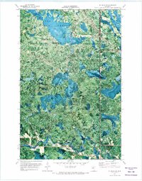
1971 Map of Wildwood SE
USGS Topo · Published 1973About this map
The Big Fork River meanders through the southern portion of this northern Minnesota landscape, where the Houck Rapids create a distinct point of navigation along the water's course. This orthophotomap, based on 1969 aerial photography, reveals a region defined by extensive timberlands and wetland systems. Three major public land tracts converge here, including the Chippewa National Forest, Pine Island State Forest, and Big Fork State Forest. The map documents a rugged, working landscape where a seasonal Winter Trail provides access through the dense vegetation. Small waterways like Plum Creek and Wade Brook feed the larger river system, while the boundary between Koochiching and Itasca counties cuts through the northern forest, marking a jurisdictional line in this remote wilderness.
Find a feature on this map
9 named features on this map. Tap any name to fly to it.
Don’t see what you’re looking for? This feature index may not catch every label — zoom into the map to look around manually.
Map Details
Editions of this 1971 Wildwood SE Map
This is the sole edition of this map. No revisions or reprints were ever made.
Other maps of this area

1918 · Zora
USGS Topo · 1:62,500

1919 · Zora
USGS Topo · 1:62,500

1919 · Marcell
USGS Topo · 1:62,500

1954 · Hibbing
USGS Topo · 1:250,000

1957 · Hibbing
USGS Topo · 1:250,000

1958 · Hibbing
USGS Topo · 1:250,000

1964 · Hibbing
USGS Topo · 1:250,000
1970 · Spring Lake
USGS Topo · 1:24,000
1970 · Bigfork
USGS Topo · 1:24,000
1970 · Wirt
USGS Topo · 1:24,000