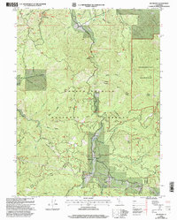
1998 Map of Wildwood
USGS Topo · Published 2003About this map
Wildwood sits at the intersection of Wildwood Road and Mad River Road, serving as a central hub in this corner of the Shasta-Trinity National Forest. The landscape is defined by the complex drainage of the South Fork Hayfork Creek and its many tributaries, including Gemmill Gulch and Goods Creek. This late-twentieth-century survey documents a transition from early homesteading and resource extraction toward conservation and recreation, evidenced by the designation of the Chanchelulla Wilderness and the Natural Bridge Scenic Area.
Find a feature on this map
50 named features on this map. Tap any name to fly to it.
Don’t see what you’re looking for? This feature index may not catch every label — zoom into the map to look around manually.
Map Details
Editions of this 1998 Wildwood Map
This is the sole edition of this map. No revisions or reprints were ever made.
Other maps of this area

1890 · Red Bluff
USGS Topo · 1:250,000

1894 · Red Bluff
USGS Topo · 1:250,000

1909 · Big Bar
USGS Topo · 1:96,000

1913 · Weaverville
USGS Topo · 1:125,000

1915 · Big Bar and Vicinity
USGS Topo · 1:250,000

1931 · Hoaglin
USGS Topo · 1:96,000

1935 · Hoaglin
USGS Topo · 1:125,000

1950 · Weaverville
USGS Topo · 1:62,500

1951 · Hayfork
USGS Topo · 1:62,500

1951 · Chanchelulla Peak
USGS Topo · 1:62,500