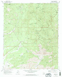
1969 Map of Wilhoit
USGS Topo · Published 1979About this map
Wilhoit and the surrounding high desert of the Prescott National Forest are documented here during a period of transition in the late 1960s. The landscape is defined by the rugged drainage basins of the Hassayampa River and Copper Basin Wash, where water management and ranching infrastructure like Telegraph Spring Windmill and Orofino Tank supported the local economy. Historical extraction is evident throughout the terrain, from the China Mine near Gabarina Hill to the Dredge Tailings along the riverbeds, indicating a long history of mineral prospecting in the area. Prominent peaks including Mt Francis and Quartz Mtn provide significant vertical relief, while the Glen Oaks (Site) marks a former settlement location. The map also details numerous springs, such as Pigeon Spring and Government Spring, which were vital waypoints in this arid environment, interconnected by a network of jeep trails and historic paths.
Find a feature on this map
47 named features on this map. Tap any name to fly to it.
Don’t see what you’re looking for? This feature index may not catch every label — zoom into the map to look around manually.
Map Details
Editions of this 1969 Wilhoit Map
3 editions found
Other maps of this area

1887 · Prescott
USGS Topo · 1:250,000

1892 · Prescott
USGS Topo · 1:250,000

1903 · Bradshaw Mountains
USGS Topo · 1:125,000

1903 · Congress
USGS Topo · 1:125,000

1904 · Congress
USGS Topo · 1:125,000

1905 · Jerome
USGS Topo · 1:125,000

1947 · Iron Springs
USGS Topo · 1:62,500

1947 · Mt. Union
USGS Topo · 1:62,500

1947 · Kirkland
USGS Topo · 1:62,500

1947 · Prescott
USGS Topo · 1:62,500