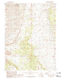
1987 Map of Wilkins Peak
USGS Topo · Published 1987About this map
Wilkins Peak dominates the northern skyline of this Sweetwater County landscape, which is defined by a complex network of dry washes and deep-cut drainages. The terrain transitions from the high elevations of Flattop Mountain in the south toward the drainage basins of Little Bitter Creek and Cedar Creek to the east. Several distinctive canyons, including Slippery Jim Canyon, Little Firehole Canyon, and Middle Firehole Canyon, illustrate the erosional patterns characteristic of the high desert plateau. A network of unimproved roads and pipelines suggests the area's mid-to-late 20th-century utility for resource extraction and land management, while the absence of permanent settlements emphasizes its character as an open, working landscape of the American West.
Find a feature on this map
11 named features on this map. Tap any name to fly to it.
Don’t see what you’re looking for? This feature index may not catch every label — zoom into the map to look around manually.
Map Details
Editions of this 1987 Wilkins Peak Map
This is the sole edition of this map. No revisions or reprints were ever made.
Other maps of this area

1908 · Rock Springs
USGS Topo · 1:62,500

1910 · Rock Springs
USGS Topo · 1:62,500

1954 · Rock Springs
USGS Topo · 1:250,000

1957 · Firehole Basin
USGS Topo · 1:62,500

1958 · Rock Springs
USGS Topo · 1:250,000

1961 · Kanda
USGS Topo · 1:24,000

1961 · Green River
USGS Topo · 1:24,000

1962 · Rock Springs
USGS Topo · 1:250,000

1966 · Firehole Basin
USGS Topo · 1:62,500
1968 · Earnest Butte
USGS Topo · 1:24,000