
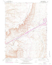
1961 Map of Kanda
USGS Topo · Published 1964About this map
The Union Pacific railroad corridor defines the development of this high-desert landscape in Sweetwater County, following the valley of Bitter Creek. The small settlement of Kanda sits at a critical junction where the modern rails parallel the historic path of the Overland Trail, illustrating the long-standing importance of this natural transportation gap. Rising sharply to the west, the escarpment of White Mountain creates a dramatic physical barrier, breached only by rugged tracks like White Mountain Road and Greens Canyon. The map records a landscape transitioning into a modern utility hub, marked by a Radio Facility (KVR), a Racetrack, and multiple Pipelines crossing the terrain. These infrastructure layers reveal how the historic westward migration route evolved into a mid-century energy and communication corridor.
Find a feature on this map
16 named features on this map. Tap any name to fly to it.
Don’t see what you’re looking for? This feature index may not catch every label — zoom into the map to look around manually.
Map Details
Editions of this 1961 Kanda Map
2 editions found
Other maps of this area

1908 · Rock Springs
USGS Topo · 1:62,500

1910 · Rock Springs
USGS Topo · 1:62,500

1954 · Rock Springs
USGS Topo · 1:250,000

1957 · Firehole Basin
USGS Topo · 1:62,500

1958 · Rock Springs
USGS Topo · 1:250,000

1961 · Scott Spring
USGS Topo · 1:24,000

1961 · Pilot Butte
USGS Topo · 1:24,000

1961 · Green River
USGS Topo · 1:24,000

1962 · Rock Springs
USGS Topo · 1:250,000

1966 · Firehole Basin
USGS Topo · 1:62,500