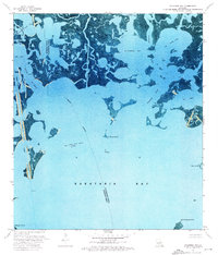
1973 Map of Wilkinson Bay
USGS Topo · Published 1976About this map
Manila Village Oil Field sits in the northwest corner of this coastal reach, representing the industrial footprint on the fragile wetlands of Jefferson and Plaquemines Parishes. This 1973 orthophotomap provides a visual record of the intricate hydrology in the Barataria Bay region, where the Barataria Waterway serves as a primary navigation corridor. The landscape is a complex network of marshes and open water, including Wilkinson Bay and Bay Chene Fleur. Deep in the bay, offshore structures such as a platform and various drill holes mark the expansion of the Oil and Gas Field into the marine environment. Landforms like St Marys Point and Big Island emerge from the water, while man-made features like the Wilkinson Canal and an underwater pipeline underscore the human engineering required to extract resources from this transition zone between the delta and the gulf.
Find a feature on this map
27 named features on this map. Tap any name to fly to it.
Don’t see what you’re looking for? This feature index may not catch every label — zoom into the map to look around manually.
Map Details
Editions of this 1973 Wilkinson Bay Map
2 editions found
Other maps of this area

1891 · Pointe a La Hache
USGS Topo · 1:62,500

1892 · Barataria
USGS Topo · 1:62,500

1892 · Creole
USGS Topo · 1:62,500

1892 · Pointe a La Hache
USGS Topo · 1:62,500

1893 · Fort Livingston
USGS Topo · 1:62,500

1935 · Bay Ronquille
USGS Topo · 1:31,680

1935 · Wilkinson Bay
USGS Topo · 1:31,680

1939 · Pointe a La Hache
USGS Topo · 1:62,500

1941 · Barataria
USGS Topo · 1:62,500

1944 · Barataria
USGS Topo · 1:62,500