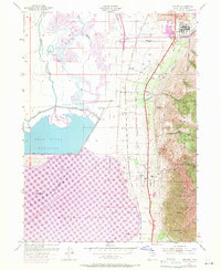
1955 Map of Willard
USGS Topo · Published 1971About this map
The Intermountain Indian School dominates the southern edge of Brigham City in this mid-century survey, representing a significant era in the region's educational and cultural history. The landscape is defined by the sharp transition between the steep peaks of the Cache National Forest and the expansive wetlands of the Bear River National Wildlife Refuge. Transportation infrastructure is a focal point, with the Union Pacific line running parallel to an Old Railroad Grade and a 4 Lane highway connecting the settlements of Perry and Willard.
Find a feature on this map
36 named features on this map. Tap any name to fly to it.
Don’t see what you’re looking for? This feature index may not catch every label — zoom into the map to look around manually.
Map Details
Editions of this 1955 Willard Map
2 editions found
Other maps of this area

1914 · Logan
USGS Topo · 1:125,000

1916 · Logan
USGS Topo · 1:125,000

1954 · Whistler Canal
USGS Topo · 1:24,000

1954 · Ogden
USGS Topo · 1:250,000

1954 · Brigham City
USGS Topo · 1:250,000

1955 · Plain City
USGS Topo · 1:24,000

1955 · Mantua
USGS Topo · 1:24,000

1955 · Plain City SW
USGS Topo · 1:24,000

1955 · Bear River City
USGS Topo · 1:24,000

1955 · Willard
USGS Topo · 1:24,000