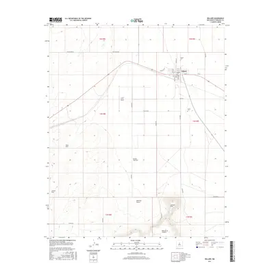
2017 Map of Willard
USGS Topo · Published 2017About this map
The high plains of Torrance County center on Willard, a village defined by its grid of residential streets such as Dalies Ave and Becker Ave. This 2017 study illustrates a landscape where small-town life meets the expansive geography of central New Mexico, marked by several local burial grounds including Willard Cem, the Protestant Cem, and the Farmer Cem further east.
Find a feature on this map
37 named features on this map. Tap any name to fly to it.
Don’t see what you’re looking for? This feature index may not catch every label — zoom into the map to look around manually.
Map Details
Editions of this 2017 Willard Map
This is the sole edition of this map. No revisions or reprints were ever made.
Other maps of this area

1917 · Estancia
USGS Topo · 1:125,000

1954 · Fort Sumner
USGS Topo · 1:250,000

1954 · Socorro
USGS Topo · 1:250,000

1956 · Mountainair
USGS Topo · 1:62,500

1958 · Socorro
USGS Topo · 1:250,000

1958 · Fort Sumner
USGS Topo · 1:250,000

1962 · Socorro
USGS Topo · 1:250,000
1972 · Mesa Draw
USGS Topo · 1:24,000
1972 · Round Top
USGS Topo · 1:24,000

1978 · Laguna Del Perro North
USGS Topo · 1:24,000