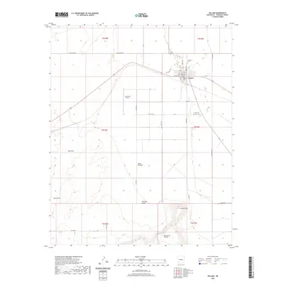
2020 Map of Willard
USGS Topo · Published 2020About this map
Willard sits at the intersection of local routes in Torrance County, serving as the primary hub for the surrounding ranching and agricultural lands. The landscape to the south transitions from the drainage basins of Tabet Draw and Chavez Draw toward the rising elevations of the Mesa de los Jumanos, which dominates the southern portion of the sheet. For those researching local families, the map identifies several burial grounds including El Rosario Cem, Willard Cem, and Farmers Cem Farmer Cem. The inclusion of the J & M Farms Airport underscores the importance of aviation in managing these expansive properties. This 2020 survey illustrates the layout of the town's grid, featuring streets like Becker Ave and Dalies Ave, while capturing the natural topography of distinctive landmarks like Jumanes Knob and Dead Dog Canyon.
Find a feature on this map
36 named features on this map. Tap any name to fly to it.
Don’t see what you’re looking for? This feature index may not catch every label — zoom into the map to look around manually.
Map Details
Editions of this 2020 Willard Map
This is the sole edition of this map. No revisions or reprints were ever made.
Other maps of this area

1917 · Estancia
USGS Topo · 1:125,000

1954 · Fort Sumner
USGS Topo · 1:250,000

1954 · Socorro
USGS Topo · 1:250,000

1956 · Mountainair
USGS Topo · 1:62,500

1958 · Socorro
USGS Topo · 1:250,000

1958 · Fort Sumner
USGS Topo · 1:250,000

1962 · Socorro
USGS Topo · 1:250,000
1972 · Mesa Draw
USGS Topo · 1:24,000
1972 · Round Top
USGS Topo · 1:24,000

1978 · Laguna Del Perro North
USGS Topo · 1:24,000