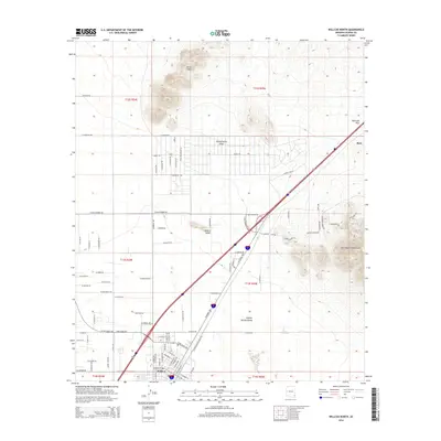
2014 Map of Willcox North
USGS Topo · Published 2014About this map
Willcox serves as the primary hub of this high-desert landscape, anchored by the Southern Pacific railroad line that cuts a diagonal path toward the northeast. This 2014 survey documents the town's expansion into the Sulphur Springs Valley, where a grid of residential roads like W Hardy Rd and N Six Gun Rd meets the open basin. To the north and east, the terrain is defined by dramatic volcanic and tectonic features including the Circle Hills, the jagged Spike Hills, and the western edge of the Dos Cabezas Mountains. The historic transport corridor through Railroad Pass remains a central feature, alongside the settlement of Raso. Inside the city, local researchers can find institutional landmarks such as the First Baptist Church and the Post Office, providing a clear record of the community's civic and spiritual layout during the early 21st century.
Find a feature on this map
92 named features on this map. Tap any name to fly to it.
Don’t see what you’re looking for? This feature index may not catch every label — zoom into the map to look around manually.
Map Details
Editions of this 2014 Willcox North Map
This is the sole edition of this map. No revisions or reprints were ever made.
Other maps of this area

1922 · Willcox
USGS Topo · 1:125,000

1943 · Dos Cabezas
USGS Topo · 1:62,500

1943 · Willcox
USGS Topo · 1:62,500

1943 · Cochise
USGS Topo · 1:62,500

1944 · Fisher Hills
USGS Topo · 1:62,500

1954 · Silver City
USGS Topo · 1:250,000

1957 · Dos Cabezas
USGS Topo · 1:62,500

1957 · Luzena
USGS Topo · 1:62,500

1958 · Silver City
USGS Topo · 1:250,000

1958 · Willcox
USGS Topo · 1:62,500