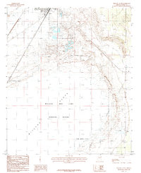
1985 Map of Willcox South
USGS Topo · Published 1985About this map
Willcox sits at the northern edge of a sprawling desert landscape defined by the massive Willcox Dry Lake Playa. This 1985 survey illustrates the intersection of local infrastructure and federal land use, notably the presence of the Willcox Dry Lake Bombing Range which occupies a significant portion of the dry lake bed south of town. The terrain is characterized by extensive Alkali Flats and low-lying depressions like the Dry Lake sections, typical of the high-desert basins in Cochise County.
Find a feature on this map
12 named features on this map. Tap any name to fly to it.
Don’t see what you’re looking for? This feature index may not catch every label — zoom into the map to look around manually.
Map Details
Editions of this 1985 Willcox South Map
This is the sole edition of this map. No revisions or reprints were ever made.
Other maps of this area

1922 · Willcox
USGS Topo · 1:125,000

1943 · Dos Cabezas
USGS Topo · 1:62,500

1943 · Willcox
USGS Topo · 1:62,500

1943 · Cochise
USGS Topo · 1:62,500

1944 · Fisher Hills
USGS Topo · 1:62,500

1954 · Silver City
USGS Topo · 1:250,000

1957 · Dos Cabezas
USGS Topo · 1:62,500

1957 · Luzena
USGS Topo · 1:62,500

1958 · Silver City
USGS Topo · 1:250,000

1958 · Willcox
USGS Topo · 1:62,500