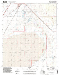
1996 Map of Willcox South
USGS Topo · Published 2002About this map
Willcox sits at the northern edge of a desert landscape dominated by the expansive Willcox Dry Lake Playa. This 1996 survey illustrates the stark transition from the town's developed outskirts, featuring a Golf Course and Sewage Disposal Ponds, to the barren stretches of the Alkali Flats. The map reveals a specialized land use pattern where the vast dry lake bed serves as the Willcox Bombing Range, a massive military installation that occupies the southern half of the quadrangle. Local industrial activity is evident through a Quarry and Gravel Pit near the town, while a major Pipeline cuts across the northern desert. These features together show a region defined by its extreme geography and its utility for both military training and resource extraction during the late twentieth century.
Find a feature on this map
11 named features on this map. Tap any name to fly to it.
Don’t see what you’re looking for? This feature index may not catch every label — zoom into the map to look around manually.
Map Details
Editions of this 1996 Willcox South Map
This is the sole edition of this map. No revisions or reprints were ever made.
Other maps of this area

1922 · Willcox
USGS Topo · 1:125,000

1943 · Dos Cabezas
USGS Topo · 1:62,500

1943 · Willcox
USGS Topo · 1:62,500

1943 · Cochise
USGS Topo · 1:62,500

1944 · Fisher Hills
USGS Topo · 1:62,500

1954 · Silver City
USGS Topo · 1:250,000

1957 · Dos Cabezas
USGS Topo · 1:62,500

1957 · Luzena
USGS Topo · 1:62,500

1958 · Silver City
USGS Topo · 1:250,000

1958 · Willcox
USGS Topo · 1:62,500