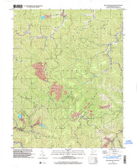
1996 Map of Williams Mountain
USGS Topo · Published 2003About this map
Peytona and the winding course of Drawdy Creek anchor the northern reaches of this Boone County landscape, which reflects a late-twentieth-century industrial and rural character. The map details the heavy influence of the extractive industry on the terrain, evidenced by extensive Strip Mine operations and a conveyor system cutting across the ridges near White Oak Creek. These industrial markings contrast with traditional community landmarks, such as Atha Chapel and family burial sites like Bias Cem and Drawdy Cem.
Find a feature on this map
52 named features on this map. Tap any name to fly to it.
Don’t see what you’re looking for? This feature index may not catch every label — zoom into the map to look around manually.
Map Details
Editions of this 1996 Williams Mountain Map
This is the sole edition of this map. No revisions or reprints were ever made.
Other maps of this area

1891 · Oceana
USGS Topo · 1:125,000

1893 · Oceana
USGS Topo · 1:125,000

1898 · Oceana
USGS Topo · 1:125,000

1899 · Charleston
USGS Topo · 1:125,000

1909 · Peytona
USGS Topo · 1:48,000

1910 · Bald Knob
USGS Topo · 1:48,000

1911 · Peytona
USGS Topo · 1:62,500

1911 · Madison
USGS Topo · 1:62,500

1912 · Bald Knob
USGS Topo · 1:62,500

1913 · Logan
USGS Topo · 1:62,500