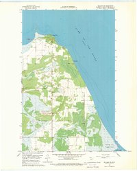
1967 Map of Williams NW
USGS Topo · Published 1969About this map
Lake Of The Woods dominates the northern and eastern portions of this late 1960s survey, illustrating the interface between the lake’s vast waters and the low-lying wetlands of northern Minnesota. The settlement at Birch Beach and the prominent terrain of Long Point serve as the primary landmarks along the shore. Inland, the landscape is defined by extensive marshes and scattered extraction sites, including several Gravel Pits and a Gravel Pit further south near Lakeroad Chapel. The presence of the Prosper Lookout Tower suggests the importance of fire surveillance in this heavily wooded and boggy region during the mid-century. Further south, the map details the early development of Zippel Bay State Park near the mouth of Zippel Bay, where small unnamed Spring labels mark the hydrology of the coastal terrain.
Find a feature on this map
15 named features on this map. Tap any name to fly to it.
Don’t see what you’re looking for? This feature index may not catch every label — zoom into the map to look around manually.
Map Details
Editions of this 1967 Williams NW Map
This is the sole edition of this map. No revisions or reprints were ever made.
Other maps of this area

1918 · Buffalo Bay
USGS Topo · 1:62,500

1918 · Roosevelt
USGS Topo · 1:62,500

1918 · Williams
USGS Topo · 1:62,500

1943 · Roosevelt
USGS Topo · 1:62,500

1954 · Roseau
USGS Topo · 1:250,000

1957 · Roseau
USGS Topo · 1:250,000

1958 · Roseau
USGS Topo · 1:250,000

1963 · Kenora
USGS Topo · 1:250,000

1967 · Williams
USGS Topo · 1:24,000
1967 · Roosevelt
USGS Topo · 1:24,000