1923 Map of Williamsport
USGS Topo · Published 1923About this map
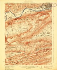
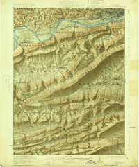
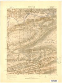
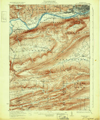
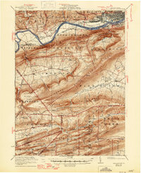
Williamsport and South Williamsport anchor the northern edge of this 1923 landscape, where the West Branch Susquehanna River carves through the central Pennsylvania ridges. An abandoned canal traces the river’s path, signaling the transition from early industrial water transport to the rail era represented by the Pennsylvania RR. The map captures a high density of rural infrastructure, including numerous educational sites like Whiteoak School and Ecktown School, alongside the distinctive geologic bowl of the Nippenose Valley. Moving south, the terrain becomes increasingly complex as it crosses into Union and Clinton counties. In these more isolated stretches, one finds remote landmarks such as the Captain Greene Monument and McCall Dam. This survey documents a moment when small settlements like Nisbet, Bastress, and Oriole were connected by a burgeoning network of state highways and country roads through the many gaps of White Deer Ridge.
Find a feature on this map
114 named features on this map. Tap any name to fly to it.
Don’t see what you’re looking for? This feature index may not catch every label — zoom into the map to look around manually.
Map Details
Editions of this 1923 Williamsport Map
6 editions found
Other maps of this area

1893 · Sunbury
USGS Topo · 1:62,500

1921 · Williamsport
USGS Topo · 1:48,000

1921 · Trout Run
USGS Topo · 1:62,500

1921 · Lock Haven
USGS Topo · 1:62,500

1923 · Lock Haven
USGS Topo · 1:62,500

1923 · Trout Run
USGS Topo · 1:62,500

1923 · Williamsport
USGS Topo · 1:62,500

1924 · Milton
USGS Topo · 1:62,500

1930 · Warrensville
USGS Topo · 1:62,500

1934 · Warrensville
USGS Topo · 1:62,500
Featured Places
- Williamsport, PA
- White Deer Township, PA
- Garden View, Old Lycoming Township
- Duboistown, PA
- Bastress Township, PA