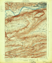
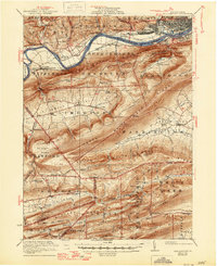
1923 Map of Williamsport
USGS Topo · Published 1932About this map
The West Branch Susquehanna River cuts a prominent path through this 1920s landscape, separating the industrial hub of Williamsport from the ridge-and-valley terrain to the south. The city's northern banks are dense with the street grids of Newberry and the main lines of the Pennsylvania railroad, while across the water, South Williamsport and Duboistown sit at the base of the formidable Eagle Mountain. This era preserves the footprint of an Abandoned Canal following the riverbank, a reminder of earlier transportation networks that once served the West Branch valley.
Find a feature on this map
113 named features on this map. Tap any name to fly to it.
Don’t see what you’re looking for? This feature index may not catch every label — zoom into the map to look around manually.
Map Details
Editions of this 1923 Williamsport Map
6 editions found
Other maps of this area

1893 · Sunbury
USGS Topo · 1:62,500

1921 · Williamsport
USGS Topo · 1:48,000

1921 · Trout Run
USGS Topo · 1:62,500

1921 · Lock Haven
USGS Topo · 1:62,500

1923 · Lock Haven
USGS Topo · 1:62,500

1923 · Trout Run
USGS Topo · 1:62,500

1923 · Williamsport
USGS Topo · 1:62,500

1924 · Milton
USGS Topo · 1:62,500

1930 · Warrensville
USGS Topo · 1:62,500

1934 · Warrensville
USGS Topo · 1:62,500
Featured Places
- Williamsport, PA
- White Deer Township, PA
- Garden View, Old Lycoming Township
- Duboistown, PA
- Bastress Township, PA