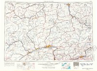
1962 Map of Williamsport
USGS Topo · Published 1966About this map
The West Branch Susquehanna River carves through the heart of north-central Pennsylvania, anchoring a region of industrial hubs and expansive wilderness. This 1960s study captures Williamsport as a bustling center of commerce, situated near the confluence of Lycoming Creek and the river. To the west, Jersey Shore and Lock Haven mark the river’s westward reach into the Allegheny Plateau, while the northern tier shows the strategic importance of towns like Sayre and Towanda along the Susquehanna River and Chemung River.
Find a feature on this map
279 named features on this map. Tap any name to fly to it.
Don’t see what you’re looking for? This feature index may not catch every label — zoom into the map to look around manually.
Map Details
Editions of this 1962 Williamsport Map
5 editions found

Other maps of this area

1889 · Catawissa
USGS Topo · 1:62,500

1889 · Hazleton
USGS Topo · 1:62,500

1891 · Wilkesbarre
USGS Topo · 1:62,500

1891 · Hazleton
USGS Topo · 1:62,500

1891 · Harveys Lake
USGS Topo · 1:62,500

1892 · Catawissa
USGS Topo · 1:62,500

1892 · Shamokin
USGS Topo · 1:62,500

1892 · Mahanoy
USGS Topo · 1:62,500

1893 · Hazleton
USGS Topo · 1:62,500

1893 · Sunbury
USGS Topo · 1:62,500