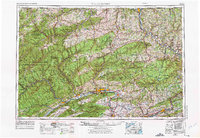
1962 Map of Williamsport
USGS Topo · Published 1975About this map
The West Branch Susquehanna River carves through the Allegheny Mountains on this mid-century survey, anchoring a region defined by its timber heritage and industrial river towns. From the lumber hub of Williamsport to the manufacturing centers of Berwick and Lock Haven, the landscape reveals a dense network of transit and natural resources. Vast tracts of public land, including the Tioga State Forest and Sproul State Forest, dominate the northern and western reaches, while the river valleys support a string of settlements like Jersey Shore and Milton.
Find a feature on this map
126 named features on this map. Tap any name to fly to it.
Don’t see what you’re looking for? This feature index may not catch every label — zoom into the map to look around manually.
Map Details
Editions of this 1962 Williamsport Map
5 editions found

Other maps of this area

1889 · Catawissa
USGS Topo · 1:62,500

1889 · Hazleton
USGS Topo · 1:62,500

1891 · Wilkesbarre
USGS Topo · 1:62,500

1891 · Hazleton
USGS Topo · 1:62,500

1891 · Harveys Lake
USGS Topo · 1:62,500

1892 · Catawissa
USGS Topo · 1:62,500

1892 · Shamokin
USGS Topo · 1:62,500

1892 · Mahanoy
USGS Topo · 1:62,500

1893 · Hazleton
USGS Topo · 1:62,500

1893 · Sunbury
USGS Topo · 1:62,500