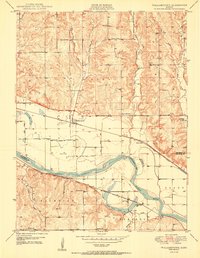
1950 Map of Williamstown
USGS Topo · Published 1950About this map
Kansas River bottomlands and the rolling hills of Jefferson County dominate this 1950 portrait of the Kansas landscape. The settlement of Williamstown serves as a central hub, situated along the Pacific Union railroad line. The map meticulously documents a rural society organized around its local institutions, showing an extensive network of country schoolhouses including Clover Hill Sch, Buck Creek Sch, and Sunnyside Sch.
Find a feature on this map
35 named features on this map. Tap any name to fly to it.
Don’t see what you’re looking for? This feature index may not catch every label — zoom into the map to look around manually.
Map Details
Editions of this 1950 Williamstown Map
3 editions found

Other maps of this area

1885 · Lawrence
USGS Topo · 1:125,000

1886 · Oskaloosa
USGS Topo · 1:125,000

1888 · Oskaloosa
USGS Topo · 1:125,000

1889 · Lawrence
USGS Topo · 1:125,000

1894 · Oskaloosa
USGS Topo · 1:125,000

1947 · Lawrence
USGS Topo · 1:250,000

1949 · Williamstown
USGS Topo · 1:24,000

1949 · Perry
USGS Topo · 1:24,000

1950 · Perry
USGS Topo · 1:24,000

1950 · Kansas City
USGS Topo · 1:250,000