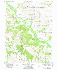
1950 Map of Williamstown
USGS Topo · Published 1977About this map
Williamstown stands at the center of this rural Lewis County landscape, characterized by the winding paths of the North Fabius River and the Middle Fabius River. In the mid-twentieth century, this region remained a patchwork of small agricultural communities and family-named landmarks. The map documents a dense network of one-room schools and country churches that anchored social life, including Walker Sch, Morris Sch, and the Providence Ch in the northeast.
Find a feature on this map
24 named features on this map. Tap any name to fly to it.
Don’t see what you’re looking for? This feature index may not catch every label — zoom into the map to look around manually.
Map Details
Editions of this 1950 Williamstown Map
2 editions found
Other maps of this area

1903 · Kahoka
USGS Topo · 1:125,000

1949 · St. Patrick
USGS Topo · 1:24,000

1950 · Saint Patrick
USGS Topo · 1:24,000

1950 · Neeper
USGS Topo · 1:24,000

1950 · Benjamin
USGS Topo · 1:24,000

1950 · Williamstown
USGS Topo · 1:24,000

1950 · Lewistown
USGS Topo · 1:24,000

1950 · Colony
USGS Topo · 1:24,000
1950 · Monticello
USGS Topo · 1:24,000

1950 · La Belle
USGS Topo · 1:24,000