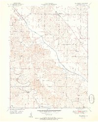
1951 Map of Williamstown
USGS Topo · Published 1951About this map
The Old Channel North Fabius River and the Middle Fabius River define the agricultural landscape of this Lewis County region during the early 1950s. The settlement of Williamstown serves as a local hub, anchored by the Williamstown Church and nearby Williamstown Cemetery. The map captures a highly decentralized educational network, typical of rural Missouri before mid-century school consolidations, featuring numerous family-named schoolhouses such as Walker School, Morris School, Turpin School, Bowls School, and Reynolds School. These small structures, often situated at rural crossroads, were the social heart of their respective neighborhoods. Smaller settlements like Hilbert and landmarks like Providence Church further illustrate the established community patterns along the timbered creek breaks and fertile uplands.
Find a feature on this map
28 named features on this map. Tap any name to fly to it.
Don’t see what you’re looking for? This feature index may not catch every label — zoom into the map to look around manually.
Map Details
Editions of this 1951 Williamstown Map
2 editions found
Other maps of this area

1903 · Kahoka
USGS Topo · 1:125,000

1949 · St. Patrick
USGS Topo · 1:24,000

1950 · Saint Patrick
USGS Topo · 1:24,000

1950 · Neeper
USGS Topo · 1:24,000

1950 · Benjamin
USGS Topo · 1:24,000

1950 · Williamstown
USGS Topo · 1:24,000

1950 · Lewistown
USGS Topo · 1:24,000

1950 · Colony
USGS Topo · 1:24,000
1950 · Monticello
USGS Topo · 1:24,000

1950 · La Belle
USGS Topo · 1:24,000