
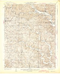
1940 Map of Williamsville
USGS Topo · Published 1940About this map
The Black River corridor defines the landscape of this 1930s survey, where the Missouri Pacific and St Louis - San Francisco railroads converge at Williamsville. This junction was a vital nexus for the timber and mineral interests of the eastern Ozarks, evidenced by the Barrett Mine and the rugged topography of Eagle Bluff. The map captures a unique cultural pocket in Budapest, a settlement founded by European immigrants, complete with its own Budapest Ch and nearby Milltown.
Find a feature on this map
77 named features on this map. Tap any name to fly to it.
Don’t see what you’re looking for? This feature index may not catch every label — zoom into the map to look around manually.
Map Details
Editions of this 1940 Williamsville Map
2 editions found
Other maps of this area

1932 · Piedmont
USGS Topo · 1:62,500

1934 · Greenville
USGS Topo · 1:62,500

1934 · Williamsville
USGS Topo · 1:48,000

1935 · Poplar Bluff
USGS Topo · 1:62,500

1935 · Piedmont
USGS Topo · 1:62,500

1935 · Acorn
USGS Topo · 1:62,500

1935 · Harviell
USGS Topo · 1:62,500

1939 · Greenville
USGS Topo · 1:62,500

1939 · Poplar Bluff
USGS Topo · 1:62,500

1939 · Doniphan
USGS Topo · 1:62,500