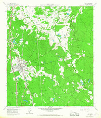
1960 Map of Willis
USGS Topo · Published 1968About this map
The town of Willis serves as the primary hub of activity in this 1960 survey, situated where the Missouri Pacific railroad meets local thoroughfares like River Road. The landscape is defined by the dense woodlands of the Sam Houston National Forest, which covers much of the eastern and northern portions of the quadrangle. Scattered throughout the clearing and forest are centers of community life, including New Hope Ch, Pleasant Rose Ch, and Turner High Sch, alongside the specialized Camp Agnes Arnold in the south.
Find a feature on this map
30 named features on this map. Tap any name to fly to it.
Don’t see what you’re looking for? This feature index may not catch every label — zoom into the map to look around manually.
Map Details
Editions of this 1960 Willis Map
3 editions found
Other maps of this area

1954 · Beaumont
USGS Topo · 1:250,000

1957 · Beaumont
USGS Topo · 1:250,000

1958 · Conroe
USGS Topo · 1:24,000

1958 · Cowl Spur
USGS Topo · 1:24,000

1958 · Lake Paula
USGS Topo · 1:24,000

1959 · Moore Grove
USGS Topo · 1:24,000

1959 · Cut and Shoot
USGS Topo · 1:24,000

1959 · Conroe NE
USGS Topo · 1:24,000

1960 · Willis
USGS Topo · 1:24,000

1960 · Maynard
USGS Topo · 1:24,000