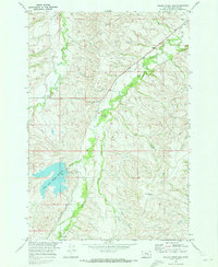
1969 Map of Willow Creek Dam
USGS Topo · Published 1973About this map
The Crow Indian Reservation landscape is defined by the critical management of water along the eastern slopes of the Bighorn Mountains. Dominating the southwest quadrant, the Lodge Grass Storage Reservoir is contained by the Willow Creek Dam, a central piece of the infrastructure developed for the Missouri River Basin project. The map illustrates a complex irrigation network essential to local ranching and agriculture, featuring the William Miller Ditch, Robert Miller Ditch, and the Lodge Grass Feeder Canal.
Find a feature on this map
21 named features on this map. Tap any name to fly to it.
Don’t see what you’re looking for? This feature index may not catch every label — zoom into the map to look around manually.
Map Details
Editions of this 1969 Willow Creek Dam Map
This is the sole edition of this map. No revisions or reprints were ever made.
Other maps of this area

1894 · Rosebud
USGS Topo · 1:125,000

1894 · St. Xavier
USGS Topo · 1:125,000

1901 · Rosebud
USGS Topo · 1:125,000

1901 · St. Xavier
USGS Topo · 1:125,000

1954 · Hardin
USGS Topo · 1:250,000

1957 · Hardin
USGS Topo · 1:250,000

1958 · Hardin
USGS Topo · 1:250,000

1960 · Schick Ranch
USGS Topo · 1:24,000

1960 · Mission Coulee
USGS Topo · 1:24,000
1967 · Wyola
USGS Topo · 1:24,000