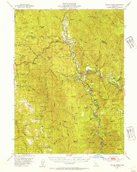
1952 Map of Willow Creek
USGS Topo · Published 1954About this map
The Trinity River and its South Fork Trinity River converge in this mid-century survey, defining a landscape of high ridges and isolated riverfront outposts. The settlement of Willow Creek serves as a central hub, situated near the northern reach of the Six Rivers National Forest. Local industry and infrastructure are evident in the scattered Placer Mines and the Horse Mtn Mine located west of Horse Mtn. Navigation across the challenging terrain is marked by a Footbridge over the Trinity and the route of State Hwy 299 winding through the canyons. Notable land holdings and administrative sites include the Cedar Grove Ranch, Lower Trinity Ranger Sta, and the Ammon Guard Sta, reflecting a period of active forest management and rural ranching. The northern boundary touches the Hoopa Valley Indian Res, while numerous creeks like Supply Creek and Madden Creek drain the surrounding heights of Brannan Mtn and Titlow Hill.
Find a feature on this map
96 named features on this map. Tap any name to fly to it.
Don’t see what you’re looking for? This feature index may not catch every label — zoom into the map to look around manually.
Map Details
Editions of this 1952 Willow Creek Map
4 editions found

Other maps of this area

1909 · Big Bar
USGS Topo · 1:96,000

1914 · Pilot Creek
USGS Topo · 1:62,500

1915 · Big Bar and Vicinity
USGS Topo · 1:250,000

1922 · Korbel
USGS Topo · 1:62,500

1922 · China Flat
USGS Topo · 1:62,500

1922 · Kneeland
USGS Topo · 1:62,500

1925 · Hoopa
USGS Topo · 1:125,000

1945 · Coyote Peak
USGS Topo · 1:62,500

1945 · Blue Lake
USGS Topo · 1:62,500

1948 · Weed
USGS Topo · 1:250,000