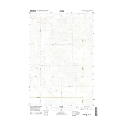
2014 Map of Willow Creek West
USGS Topo · Published 2014About this map
The rolling grasslands along the Dunn, Mercer, and Stark county lines are defined by the winding course of the Knife River. This high-plains landscape features the significant branch known as the Br Knife River, which meanders through the central and southern portions of the territory. In the northern reaches, the waters of Schaffner Cr flow across the section lines of this sparsely settled prairie. The map documents the rural road grid in the early 21st century, showing the intersection of local section roads such as 23rd St SW and 81st Ave SW, which provide the primary access to these remote agricultural reaches of North Dakota.
Find a feature on this map
3 named features on this map. Tap any name to fly to it.
Don’t see what you’re looking for? This feature index may not catch every label — zoom into the map to look around manually.
Map Details
Editions of this 2014 Willow Creek West Map
This is the sole edition of this map. No revisions or reprints were ever made.
Other maps of this area

1953 · Dickinson
USGS Topo · 1:250,000

1953 · Watford City
USGS Topo · 1:250,000

1957 · Dickinson
USGS Topo · 1:250,000

1957 · Watford City
USGS Topo · 1:250,000

1967 · Watford City
USGS Topo · 1:250,000

1973 · Marshall SE
USGS Topo · 1:24,000
1973 · Hebron
USGS Topo · 1:24,000

1973 · Schaffner Creek NE
USGS Topo · 1:24,000

1973 · Willow Creek West
USGS Topo · 1:24,000

1973 · Schaffner Creek
USGS Topo · 1:24,000