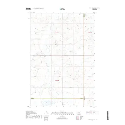
2017 Map of Willow Creek West
USGS Topo · Published 2017About this map
The Knife River meanders through this section of the North Dakota prairie, joined by the Br Knife River in a landscape defined by its wide river valleys and high plains. This 2017 survey documents the intersection of three counties — Dunn, Mercer, and Stark — highlighting the rural infrastructure of the region. The map shows a strictly organized grid of sectional roads, including Co Rd 3 and 82nd Ave SW, which provide access to the remote agricultural lands. Small wetlands are scattered in the southern reaches, while the drainage of Willow Cr marks the eastern boundary. This map is a clean record of the Great Plains' topography, capturing the precise path of the waterways and the township boundaries of t142n r91w and t141n r91w as they existed in the early 21st century.
Find a feature on this map
22 named features on this map. Tap any name to fly to it.
Don’t see what you’re looking for? This feature index may not catch every label — zoom into the map to look around manually.
Map Details
Editions of this 2017 Willow Creek West Map
This is the sole edition of this map. No revisions or reprints were ever made.
Other maps of this area

1953 · Dickinson
USGS Topo · 1:250,000

1953 · Watford City
USGS Topo · 1:250,000

1957 · Dickinson
USGS Topo · 1:250,000

1957 · Watford City
USGS Topo · 1:250,000

1967 · Watford City
USGS Topo · 1:250,000

1973 · Marshall SE
USGS Topo · 1:24,000
1973 · Hebron
USGS Topo · 1:24,000

1973 · Schaffner Creek NE
USGS Topo · 1:24,000

1973 · Willow Creek West
USGS Topo · 1:24,000

1973 · Schaffner Creek
USGS Topo · 1:24,000