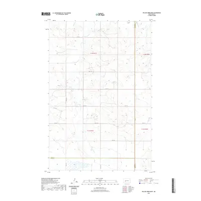
2020 Map of Willow Creek West
USGS Topo · Published 2020About this map
The Knife River and its tributary, the Br Knife River, define the undulating topography of this landscape where the borders of Stark, Dunn, and Mercer counties meet. This region in western North Dakota is characterized by a sparse, systematic grid of section lines and rural thoroughfares such as 82nd Ave SW and Co Rd 3. The drainage patterns of Willow Cr in the east and the river forks to the west suggest a terrain shaped by erosion, with complex contouring that reveals the breaks and draws typical of the Missouri Plateau. Settlement is minimal, focused on the connectivity provided by gravel routes like 25th St SW and 27th St SW, reflecting a modern agricultural era where vast open spaces and water access dictate the local geography.
Find a feature on this map
20 named features on this map. Tap any name to fly to it.
Don’t see what you’re looking for? This feature index may not catch every label — zoom into the map to look around manually.
Map Details
Editions of this 2020 Willow Creek West Map
This is the sole edition of this map. No revisions or reprints were ever made.
Other maps of this area

1953 · Dickinson
USGS Topo · 1:250,000

1953 · Watford City
USGS Topo · 1:250,000

1957 · Dickinson
USGS Topo · 1:250,000

1957 · Watford City
USGS Topo · 1:250,000

1967 · Watford City
USGS Topo · 1:250,000

1973 · Marshall SE
USGS Topo · 1:24,000
1973 · Hebron
USGS Topo · 1:24,000

1973 · Schaffner Creek NE
USGS Topo · 1:24,000

1973 · Willow Creek West
USGS Topo · 1:24,000

1973 · Schaffner Creek
USGS Topo · 1:24,000