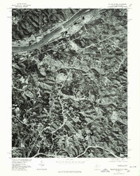
1976 Map of Willow Island
USGS Topo · Published 1979About this map
Industrial and agricultural patterns along the Ohio River define this orthophotoquad, which utilizes imagery from March 1976. The high-contrast aerial perspective reveals the dense woodland and cleared ridge-top farms typical of this stretch of the Ohio Valley. At the northern bend of the river, the settlement of Willow Island is visible alongside significant industrial infrastructure near the shoreline. Further upstream, the small community of Eureka sits on the riverbank, while Deerwalk occupies the interior hilly terrain to the south. Produced in cooperation with the Soil Conservation Service, this document provides a detailed look at land use and vegetation cover during the mid-1970s, capturing the footprint of the river-oriented economy before modern developments altered the landscape.
Find a feature on this map
4 named features on this map. Tap any name to fly to it.
Don’t see what you’re looking for? This feature index may not catch every label — zoom into the map to look around manually.
Map Details
Editions of this 1976 Willow Island Map
This is the sole edition of this map. No revisions or reprints were ever made.
Other maps of this area

1904 · Marietta
USGS Topo · 1:62,500

1906 · Saint Marys
USGS Topo · 1:62,500

1906 · Elizabeth
USGS Topo · 1:62,500

1907 · Harrisville
USGS Topo · 1:62,500

1924 · St Marys
USGS Topo · 1:62,500

1924 · Harrisville
USGS Topo · 1:62,500

1924 · Marietta
USGS Topo · 1:62,500

1924 · Elizabeth
USGS Topo · 1:62,500

1926 · Elizabeth
USGS Topo · 1:62,500

1926 · Harrisville
USGS Topo · 1:62,500