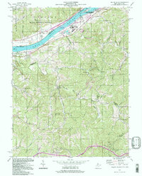
1994 Map of Willow Island
USGS Topo · Published 1998About this map
The Ohio River corridor defines this borderlands region between Ohio and West Virginia, where industrial and natural landscapes converge at the Willow Island Locks and Dam. This mid-century survey, photo-inspected in the 1990s, reveals a terrain deeply influenced by resource extraction, anchored by the Volcano Oil Field in the south and various pipelines traversing the ridges. The distribution of small settlements like Waverly, Eureka, and Horseneck reflects a historic reliance on river transport and valley agriculture, while the uplands are marked by landmarks such as Pumpkin Knob Sch and the Middle Ridge Ch. A significant portion of the riverfront and upland territory is preserved within the Wayne National Forest and the Ohio River Islands National Wildlife Refuge, illustrating the transition from 19th-century industrial use to modern conservation efforts along the banks of McElroys Run and Cow Creek.
Find a feature on this map
53 named features on this map. Tap any name to fly to it.
Don’t see what you’re looking for? This feature index may not catch every label — zoom into the map to look around manually.
Map Details
Editions of this 1994 Willow Island Map
This is the sole edition of this map. No revisions or reprints were ever made.
Other maps of this area

1904 · Marietta
USGS Topo · 1:62,500

1906 · Saint Marys
USGS Topo · 1:62,500

1906 · Elizabeth
USGS Topo · 1:62,500

1907 · Harrisville
USGS Topo · 1:62,500

1924 · St Marys
USGS Topo · 1:62,500

1924 · Harrisville
USGS Topo · 1:62,500

1924 · Marietta
USGS Topo · 1:62,500

1924 · Elizabeth
USGS Topo · 1:62,500

1926 · Elizabeth
USGS Topo · 1:62,500

1926 · Harrisville
USGS Topo · 1:62,500