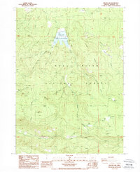
1988 Map of Willow Lake
USGS Topo · Published 1988About this map
Willow Lake serves as a central hub for water management and recreation within the expansive Rogue River National Forest. This high-elevation terrain is defined by its complex drainage systems, including Willow Creek and Fourbit Creek, which feed into the reservoir. The presence of the Spillway and Sewer Disposal Ponds indicates the engineered infrastructure required to maintain this remote recreation area during the late 1980s.
Find a feature on this map
55 named features on this map. Tap any name to fly to it.
Don’t see what you’re looking for? This feature index may not catch every label — zoom into the map to look around manually.
Map Details
Editions of this 1988 Willow Lake Map
This is the sole edition of this map. No revisions or reprints were ever made.
Other maps of this area

1891 · Ashland
USGS Topo · 1:250,000

1893 · Ashland
USGS Topo · 1:250,000

1897 · Ashland
USGS Topo · 1:250,000

1938 · Medford
USGS Topo · 1:125,000

1954 · Butte Falls
USGS Topo · 1:62,500

1954 · Lakecreek
USGS Topo · 1:62,500

1955 · Rustler Peak
USGS Topo · 1:62,500

1955 · Mt. Mc Loughlin
USGS Topo · 1:62,500

1955 · Medford
USGS Topo · 1:250,000

1957 · Medford
USGS Topo · 1:250,000