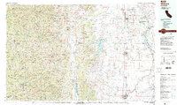
1987 Map of Willows
USGS Topo · Published 1988About this map
Black Butte Lake and the Stony Gorge Reservoir anchor this late-1980s landscape, illustrating the water management systems essential to the northern Sacramento Valley. The contrast between the grid-work agriculture of the valley floor and the dramatic rise of the Mendocino National Forest defines the regional geography. Transportation and energy infrastructure are prominent, with the Southern Pacific rail line and Pacific Highway paralleling the Sacramento River, while the Corning Gas Field and Malton Gas Field mark the subsurface industrial activity near Corning.
Find a feature on this map
78 named features on this map. Tap any name to fly to it.
Don’t see what you’re looking for? This feature index may not catch every label — zoom into the map to look around manually.
Map Details
Editions of this 1987 Willows Map
2 editions found
Other maps of this area

1886 · Lassen Peak
USGS Topo · 1:250,000

1888 · Marysville
USGS Topo · 1:125,000

1890 · Red Bluff
USGS Topo · 1:250,000

1891 · Chico
USGS Topo · 1:125,000

1891 · Marysville
USGS Topo · 1:125,000

1892 · Lassen Peak
USGS Topo · 1:250,000

1893 · Chico
USGS Topo · 1:125,000

1894 · Lassen Peak
USGS Topo · 1:250,000

1894 · Marysville
USGS Topo · 1:125,000

1894 · Red Bluff
USGS Topo · 1:250,000