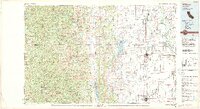
1987 Map of Willows
USGS Topo · Published 1988About this map
Mendocino National Forest dominates the western half of this landscape, where high peaks like Hull Mountain and Anthony Peak overlook a complex drainage system including the Black Butte River and Eel River. The terrain transitions sharply from these highlands to the agricultural Sacramento Valley floor, where the Sacramento River forms the eastern boundary near Corning and Hamilton City. Water management is central to the valley's development, evidenced by the presence of Black Butte Lake and the Stony Gorge Reservoir along Stony Creek. The north-south corridor of Interstate 5 and the Southern Pacific railroad connect the primary settlements of Willows, Orland, and Richfield. Smaller communities such as Newville, Chrome, and Lodoga sit at the interface of the valley and the foothills, marking the historical extent of ranching and early commerce in this part of Glenn and Tehama counties.
Find a feature on this map
90 named features on this map. Tap any name to fly to it.
Don’t see what you’re looking for? This feature index may not catch every label — zoom into the map to look around manually.
Map Details
Editions of this 1987 Willows Map
2 editions found
Other maps of this area

1886 · Lassen Peak
USGS Topo · 1:250,000

1888 · Marysville
USGS Topo · 1:125,000

1890 · Red Bluff
USGS Topo · 1:250,000

1891 · Chico
USGS Topo · 1:125,000

1891 · Marysville
USGS Topo · 1:125,000

1892 · Lassen Peak
USGS Topo · 1:250,000

1893 · Chico
USGS Topo · 1:125,000

1894 · Lassen Peak
USGS Topo · 1:250,000

1894 · Marysville
USGS Topo · 1:125,000

1894 · Red Bluff
USGS Topo · 1:250,000