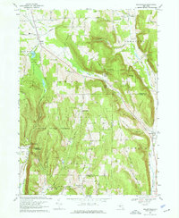
1969 Map of Willseyville
USGS Topo · Published 1971About this map
Danby State Forest dominates the high ground of southern Tompkins County in this 1960s revision, a landscape defined by steep wooded ridges and narrow agricultural valleys. The topography is shaped by prominent heights such as Steventown Hill, Durfee Hill, and Roundtop, which overlook the scattered settlements of Danby, Caroline, and Willseyville. The Lehigh Valley Railroad follows the natural grade of the valley floor, paralleling Willseyville Creek as it moves toward the Tioga County line. Local heritage is preserved in the numerous cemeteries and early educational sites, including the Danby Rural Cem, Lane Cem, and the Grove School. A distinctive feature of the north is Buttermilk Falls State Park, where Buttermilk Creek begins its descent. The map also reveals an industrial layer with several Gravel Pit locations and a major pipeline traversing the hills, reflecting the region's mid-century utility and infrastructure development.
Find a feature on this map
71 named features on this map. Tap any name to fly to it.
Don’t see what you’re looking for? This feature index may not catch every label — zoom into the map to look around manually.
Map Details
Editions of this 1969 Willseyville Map
4 editions found
Other maps of this area

1893 · Ithaca
USGS Topo · 1:62,500

1895 · Ithaca
USGS Topo · 1:62,500

1900 · Dryden
USGS Topo · 1:62,500

1902 · Waverly
USGS Topo · 1:62,500

1903 · Owego
USGS Topo · 1:62,500

1905 · Watkins Glen
USGS Topo · 1:125,000

1906 · Catatonk
USGS Topo · 1:125,000

1949 · Ithaca West
USGS Topo · 1:24,000

1949 · Ithaca East
USGS Topo · 1:24,000

1949 · Willseyville
USGS Topo · 1:24,000