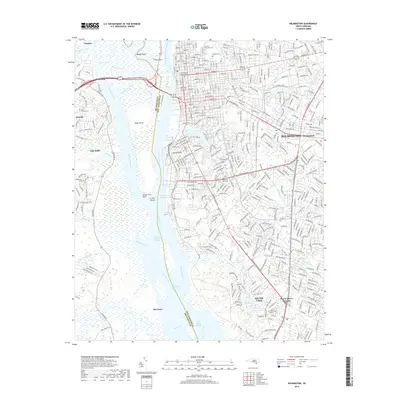
2019 Map of Wilmington
USGS Topo · Published 2019About this map
Eagle Island sits at the heart of this coastal landscape, bifurcated by the Northeast Cape Fear River and the main channel of the Cape Fear River. The city of Wilmington dominates the eastern bank, showcasing a dense grid of streets and significant historical sites like Oakdale Cem and the Saint James Episcopal Cem. Across the water, the western shore transitions into the marshy reaches of Alligator Creek and Jackeys Creek, where the settlements of Leland, Belville, and Navassa represent the expanding footprint of the region. Navigational markers such as the Fourth East Jetty Range and Upper Brunswick Range indicate the importance of the maritime corridor. To the south, the landscape features Silver Lake and the residential community of Myrtle Grove Junction, while multiple smaller waterways like Hewletts Creek and Barnards Creek drain the coastal plain.
Find a feature on this map
50 named features on this map. Tap any name to fly to it.
Don’t see what you’re looking for? This feature index may not catch every label — zoom into the map to look around manually.
Map Details
Editions of this 2019 Wilmington Map
This is the sole edition of this map. No revisions or reprints were ever made.
Other maps of this area

1942 · Wilmington
USGS Topo · 1:62,500

1943 · Funston
USGS Topo · 1:24,000

1943 · Winnabow
USGS Topo · 1:24,000

1944 · Winnabow
USGS Topo · 1:31,680

1947 · Rocky Point
USGS Topo · 1:62,500

1948 · Wilmington
USGS Topo · 1:62,500

1950 · Winnabow
USGS Topo · 1:25,000

1953 · Florence
USGS Topo · 1:250,000

1953 · Beaufort
USGS Topo · 1:250,000

1954 · Florence
USGS Topo · 1:250,000