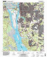
1993 Map of Wilmington
USGS Topo · Published 1999About this map
The Cape Fear River and Brunswick River converge to define this coastal landscape, isolating the large expanse of Eagle Island between their channels. In the 1990s, the urban footprint of Wilmington shows significant density, with civic and cultural landmarks like the USS North Carolina Battleship Memorial and the University of North Carolina at Wilmington serving as anchors. The maritime and industrial character of the waterfront is evidenced by the State Ports Authority facilities and the network of the Seaboard Coast Line railroad tracks serving the docks.
Find a feature on this map
69 named features on this map. Tap any name to fly to it.
Don’t see what you’re looking for? This feature index may not catch every label — zoom into the map to look around manually.
Map Details
Editions of this 1993 Wilmington Map
This is the sole edition of this map. No revisions or reprints were ever made.
Other maps of this area

1942 · Wilmington
USGS Topo · 1:62,500

1943 · Funston
USGS Topo · 1:24,000

1943 · Winnabow
USGS Topo · 1:24,000

1944 · Winnabow
USGS Topo · 1:31,680

1947 · Rocky Point
USGS Topo · 1:62,500

1948 · Wilmington
USGS Topo · 1:62,500

1950 · Winnabow
USGS Topo · 1:25,000

1953 · Florence
USGS Topo · 1:250,000

1953 · Beaufort
USGS Topo · 1:250,000

1954 · Florence
USGS Topo · 1:250,000