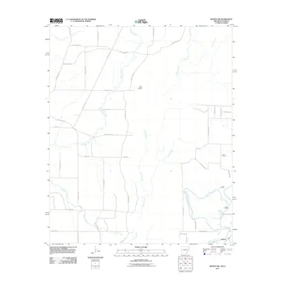
2011 Map of Wilmot SW
USGS Topo · Published 2011About this map
Bayou Bartholomew snakes through the southeastern corner of this landscape, anchoring the small community of McGinty just north of the Louisiana border. The terrain is defined by a dense network of watercourses, including White Oak Creek, Hurricane Creek, and Overflow Creek, which drain the lowlands between Arkansas and Louisiana. This 2011 survey reveals a landscape primarily organized around rural county roads and agriculture, with numerous family-named and local burial sites such as Poley Bridge Cemetery, Harris Cemetery, and Grant Cemetery dotting the map. The presence of State Line Rd marks the jurisdictional boundary, while features like Gaines Slough highlight the naturally wet, alluvial nature of the region. Local transit is facilitated by a grid of named routes like Ashley Road 318 and Marvin McKoin Rd, providing a clear record of local infrastructure at the start of the 2010s.
Find a feature on this map
45 named features on this map. Tap any name to fly to it.
Don’t see what you’re looking for? This feature index may not catch every label — zoom into the map to look around manually.
Map Details
Editions of this 2011 Wilmot SW Map
This is the sole edition of this map. No revisions or reprints were ever made.
Other maps of this area

1935 · Wilmot
USGS Topo · 1:62,500

1935 · Naff
USGS Topo · 1:62,500

1935 · Bonita
USGS Topo · 1:62,500

1953 · Greenwood
USGS Topo · 1:250,000

1955 · Jackson
USGS Topo · 1:250,000

1956 · Greenwood
USGS Topo · 1:250,000

1956 · Bastrop
USGS Topo · 1:62,500

1958 · Bonita
USGS Topo · 1:62,500

1960 · Wilmot
USGS Topo · 1:62,500
1960 · Portland
USGS Topo · 1:24,000