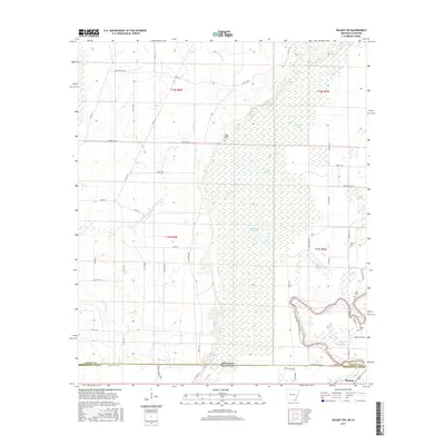
2017 Map of Wilmot SW
USGS Topo · Published 2017About this map
Bayou Bartholomew meanders through the southeast corner of this survey, defining a landscape shaped by the intricate hydrology of the Arkansas-Louisiana border. The settlement of McGinty sits near the state line in Morehouse Parish, marking a transition from the dense wetlands of the east to the slightly higher ground of the west. This territory is defined by an extensive network of sloughs and brakes, including Thompson Brake and Glover Brake, which illustrate the complex drainage patterns common to this section of the Mississippi Delta region. The presence of several family or community burial grounds, such as Grant Cem, Bethel Cem, and Harris Cem, indicates a legacy of rural settlement tied closely to the land and its waterways. Extensive forest and wetland areas are punctuated by small creek systems like Hurricane Cr and Overflow Cr, while a network of named trails, including Barthol Trl and Oscar Franklin Trl, provide access through the dense bottomlands.
Find a feature on this map
59 named features on this map. Tap any name to fly to it.
Don’t see what you’re looking for? This feature index may not catch every label — zoom into the map to look around manually.
Map Details
Editions of this 2017 Wilmot SW Map
This is the sole edition of this map. No revisions or reprints were ever made.
Other maps of this area

1935 · Wilmot
USGS Topo · 1:62,500

1935 · Naff
USGS Topo · 1:62,500

1935 · Bonita
USGS Topo · 1:62,500

1953 · Greenwood
USGS Topo · 1:250,000

1955 · Jackson
USGS Topo · 1:250,000

1956 · Greenwood
USGS Topo · 1:250,000

1956 · Bastrop
USGS Topo · 1:62,500

1958 · Bonita
USGS Topo · 1:62,500

1960 · Wilmot
USGS Topo · 1:62,500
1960 · Portland
USGS Topo · 1:24,000