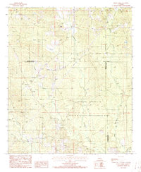
1986 Map of Wilson Creek
USGS Topo · Published 1986About this map
The Dugdemona River meanders through this portion of North Louisiana, defining a landscape shaped by bottomland drainage and timbered ridges. As of the mid-1980s, the small settlement of Wilson stands as a primary point of reference in an area otherwise dominated by the intersections of Wilson Creek and Dry Cypress Creek. The map reveals a transition between the elevated parish lands and the low-lying basins of the Madden Creek watershed, illustrating the rural character and water-dependent geography of the region during this era. This provisional survey captures the distribution of rural dwellings and the hydraulic network before further modern development altered the local watercourses.
Find a feature on this map
5 named features on this map. Tap any name to fly to it.
Don’t see what you’re looking for? This feature index may not catch every label — zoom into the map to look around manually.
Map Details
Editions of this 1986 Wilson Creek Map
This is the sole edition of this map. No revisions or reprints were ever made.
Other maps of this area

1947 · Bienville
USGS Topo · 1:62,500

1949 · Bienville
USGS Topo · 1:62,500

1950 · Ruston
USGS Topo · 1:62,500

1950 · Arcadia
USGS Topo · 1:62,500

1951 · Arcadia
USGS Topo · 1:62,500

1951 · Ruston
USGS Topo · 1:62,500

1953 · Hodge
USGS Topo · 1:62,500

1955 · Shreveport
USGS Topo · 1:250,000

1956 · Shreveport
USGS Topo · 1:250,000

1984 · Shreveport
USGS Topo · 1:250,000