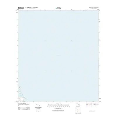
2012 Map of Wilson OE E
USGS Topo · Published 2012About this map
Playalinda Beach dominates the western shoreline in this coastal survey, where the Atlantic coast meets the interior wetlands of Brevard County. The map focuses primarily on the vast expanse of the Atlantic Ocean, which covers nearly the entire quadrangle east of the shoreline. Along the narrow coastal strip, Bald Pate Creek winds through the marshes just inland from the beach, illustrating the delicate transition between the open sea and the Florida mainland. This digital-era rendering by the U.S. Geological Survey provides a clear view of the undeveloped shoreline before the further environmental changes of the early 21st century.
Find a feature on this map
3 named features on this map. Tap any name to fly to it.
Don’t see what you’re looking for? This feature index may not catch every label — zoom into the map to look around manually.
Map Details
Editions of this 2012 Wilson OE E Map
This is the sole edition of this map. No revisions or reprints were ever made.
Other maps of this area

1949 · Pardon Island
USGS Topo · 1:24,000

1949 · Orsino
USGS Topo · 1:24,000

1949 · False Cape
USGS Topo · 1:24,000

1949 · Wilson
USGS Topo · 1:24,000

1951 · False Cape
USGS Topo · 1:24,000

1951 · Orsino
USGS Topo · 1:24,000

1952 · Wilson
USGS Topo · 1:24,000
1952 · Pardon Island
USGS Topo · 1:24,000

1955 · Orlando
USGS Topo · 1:250,000

1957 · Orlando
USGS Topo · 1:250,000