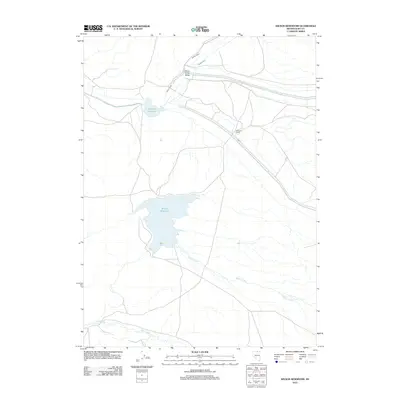
2012 Map of Wilson Reservoir
USGS Topo · Published 2012About this map
Wilson Reservoir and the adjacent Rawhide Reservoir dominate this high-desert basin in northern Elko County. The landscape is defined by the hydrologic network of Indian Creek and Silver Creek, which feed into the northern valleys before draining toward the central reservoirs. This 2012 survey illustrates the vital role of water management in the Great Basin, where man-made catchments provide essential resources for local ranching operations. Evidence of this agricultural heritage is grounded at Mitchum Ranch, a solitary named outpost situated near the branching drainages of Wilson Creek. The terrain transitions from the broad Silver Creek Valley in the north to the southern reaches where Deep Creek cuts through the more varied topography. This map serves as a detailed record of water infrastructure and land use in a region where isolated ranching and resource management are the primary drivers of settlement.
Find a feature on this map
8 named features on this map. Tap any name to fly to it.
Don’t see what you’re looking for? This feature index may not catch every label — zoom into the map to look around manually.
Map Details
Editions of this 2012 Wilson Reservoir Map
This is the sole edition of this map. No revisions or reprints were ever made.
Other maps of this area

1939 · Owyhee
USGS Topo · 1:62,500

1942 · Owyhee
USGS Topo · 1:62,500

1955 · McDermitt
USGS Topo · 1:250,000

1956 · Bull Run
USGS Topo · 1:62,500

1959 · McDermitt
USGS Topo · 1:250,000

1964 · Hat Peak
USGS Topo · 1:62,500

1964 · Wilson Reservoir
USGS Topo · 1:62,500
1971 · Dry Creek Reservoir
USGS Topo · 1:24,000

1982 · Bull Run Mts
USGS Topo · 1:100,000
1987 · Fourmile Butte
USGS Topo · 1:24,000