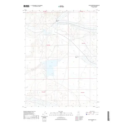
2018 Map of Wilson Reservoir
USGS Topo · Published 2018About this map
Wilson Reservoir sits at the center of this landscape, serving as a primary water source in this corner of Elko County. The terrain is defined by the broad Silver Creek Valley to the north and the narrowing Wilson Creek Canyon to the east. Waterways such as Silver Creek and Indian Cr drain through the high-elevation basin, illustrating the drainage patterns vital to ranching and land management in the high desert. Public Land Survey System grids, including t44n r50e and t43n r51e, frame the topography, providing a precise spatial context for property and resource boundaries in this rural Nevada territory.
Find a feature on this map
11 named features on this map. Tap any name to fly to it.
Don’t see what you’re looking for? This feature index may not catch every label — zoom into the map to look around manually.
Map Details
Editions of this 2018 Wilson Reservoir Map
This is the sole edition of this map. No revisions or reprints were ever made.
Other maps of this area

1939 · Owyhee
USGS Topo · 1:62,500

1942 · Owyhee
USGS Topo · 1:62,500

1955 · McDermitt
USGS Topo · 1:250,000

1956 · Bull Run
USGS Topo · 1:62,500

1959 · McDermitt
USGS Topo · 1:250,000

1964 · Hat Peak
USGS Topo · 1:62,500

1964 · Wilson Reservoir
USGS Topo · 1:62,500
1971 · Dry Creek Reservoir
USGS Topo · 1:24,000

1982 · Bull Run Mts
USGS Topo · 1:100,000
1987 · Fourmile Butte
USGS Topo · 1:24,000