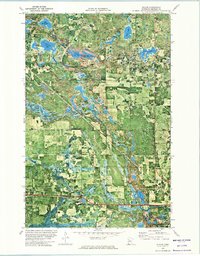
1972 Map of Wilton
USGS Topo · Published 1974About this map
The Mississippi Headwaters State Forest dominates this landscape in northern Minnesota, where dense woodlands are broken by an intricate system of lakes and wetlands. The orthophotomap format reveals the actual density of the forest canopy and the precise shoreline of Grant Lake, Wolf Lake, and the smaller Little Buzzle Lake to the north. Settlement is concentrated along the transportation corridors, particularly where the Burlington Northern railroad runs through the village of Wilton.
Find a feature on this map
25 named features on this map. Tap any name to fly to it.
Don’t see what you’re looking for? This feature index may not catch every label — zoom into the map to look around manually.
Map Details
Editions of this 1972 Wilton Map
This is the sole edition of this map. No revisions or reprints were ever made.
Other maps of this area

1919 · Solway
USGS Topo · 1:62,500

1920 · Buena Vista
USGS Topo · 1:62,500

1943 · Solway
USGS Topo · 1:62,500

1954 · Bemidji
USGS Topo · 1:250,000

1957 · Bemidji
USGS Topo · 1:250,000

1958 · Bemidji
USGS Topo · 1:250,000

1968 · Bemidji West
USGS Topo · 1:24,000

1972 · Alida
USGS Topo · 1:24,000

1972 · Peterson Lake
USGS Topo · 1:24,000
1972 · Debs
USGS Topo · 1:24,000