
1962 Map of Winamac
USGS Topo · Published 1964About this map
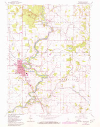
The Tippecanoe River meanders dramatically through Pulaski County, defining the landscape and providing a focal point for the Tippecanoe River State Park and the adjacent Winamac State Fish and Game Area. The town of Winamac serves as the local hub, its grid extending toward the riverbanks where City Park and the Pennsylvania RR corridor converge. This 1960s survey illustrates a rural economy transitioning into a managed recreational landscape, evidenced by the extensive network of drainage projects like Anstis Ditch and Breckenridge Ditch that crisscross the surrounding townships of Franklin, Tippecanoe, Monroe, and Harrison. Genealogists will find significant value in the documentation of several burial sites, including St Peters Cem, Crown Hill Cem, and the Memorial Gardens, while several country school sites like Fairview Sch remained landmark features in the rural landscape.
Find a feature on this map
57 named features on this map. Tap any name to fly to it.
Don’t see what you’re looking for? This feature index may not catch every label — zoom into the map to look around manually.
Map Details
Editions of this 1962 Winamac Map
2 editions found
Other maps of this area

1953 · Chicago
USGS Topo · 1:250,000

1953 · Danville
USGS Topo · 1:250,000

1955 · Danville
USGS Topo · 1:250,000

1956 · Danville
USGS Topo · 1:250,000

1957 · Chicago
USGS Topo · 1:250,000

1960 · Grass Creek
USGS Topo · 1:24,000

1962 · Buffalo
USGS Topo · 1:24,000

1962 · Star City
USGS Topo · 1:24,000

1962 · Kewanna
USGS Topo · 1:24,000

1962 · Denham
USGS Topo · 1:24,000