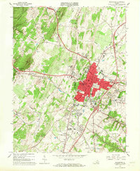
1966 Map of Winchester
USGS Topo · Published 1967About this map
Winchester serves as a dense urban core for Frederick County, flanked by the prominent ridge lines of North Mountain, Apple Pie Ridge, and Hunting Ridge. The landscape in the mid-1960s is defined by a mix of agricultural heritage and emerging suburban infrastructure, where orchards and ridges meet the expanding edges of the city. Historical sites are scattered throughout, including the remains of Star Fort and Fort Milroy north of town. The transport network is anchored by several rail lines, including the Baltimore and Ohio Railroad and the Winchester and Western Railroad, which move through the valleys alongside creeks like Abrams Creek and Redbud Run. To the south, Kernstown and the Winchester Municipal Airport mark the southern corridor, while institutional landmarks such as Shenandoah College and the VPI Experimental Sta highlight the region's educational and scientific contributions.
Find a feature on this map
70 named features on this map. Tap any name to fly to it.
Don’t see what you’re looking for? This feature index may not catch every label — zoom into the map to look around manually.
Map Details
Editions of this 1966 Winchester Map
4 editions found
Other maps of this area

1894 · Winchester
USGS Topo · 1:125,000

1914 · Gerrardstown
USGS Topo · 1:48,000

1916 · Gerrardstown
USGS Topo · 1:62,500

1916 · Capon Bridge
USGS Topo · 1:62,500

1923 · Middletown
USGS Topo · 1:62,500

1923 · Capon Bridge
USGS Topo · 1:62,500

1937 · Capon Bridge
USGS Topo · 1:48,000

1937 · Gerrardstown
USGS Topo · 1:48,000

1937 · Middletown
USGS Topo · 1:48,000

1938 · Winchester
USGS Topo · 1:48,000