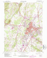
1966 Map of Winchester
USGS Topo · Published 1987About this map
The city of Winchester serves as the hub of this mid-century survey, surrounded by the orchards of Apple Pie Ridge and the heights of Little North Mountain. The landscape reveals a dense network of institutional and religious history, from the sprawling Mt Hebron Cemetery near the city center to the Old Opequon Ch and Old Opequon Cem south at Kernstown. The transition from rural to suburban is evident in the residential development at Frederick Heights and Hill Crest.
Find a feature on this map
58 named features on this map. Tap any name to fly to it.
Don’t see what you’re looking for? This feature index may not catch every label — zoom into the map to look around manually.
Map Details
Editions of this 1966 Winchester Map
4 editions found
Other maps of this area

1894 · Winchester
USGS Topo · 1:125,000

1914 · Gerrardstown
USGS Topo · 1:48,000

1916 · Gerrardstown
USGS Topo · 1:62,500

1916 · Capon Bridge
USGS Topo · 1:62,500

1923 · Middletown
USGS Topo · 1:62,500

1923 · Capon Bridge
USGS Topo · 1:62,500

1937 · Capon Bridge
USGS Topo · 1:48,000

1937 · Gerrardstown
USGS Topo · 1:48,000

1937 · Middletown
USGS Topo · 1:48,000

1938 · Winchester
USGS Topo · 1:48,000