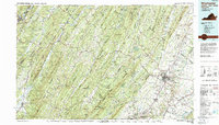
1983 Map of Winchester
USGS Topo · Published 1987About this map
The Winchester area, spanning the borderlands of Virginia and West Virginia, is defined by the corrugated ridges of the Appalachians and the fertile valleys that supported early colonial settlement and later industrial expansion. Winchester itself serves as a dense urban hub, connected to outlying towns like Stephens City and Berryville via a network including Interstate 81 and US Highway 50. The landscape is dominated by long, parallel elevations such as North Mountain and Sideling Hill, which channel the flow of the Shenandoah River and the Cacapon River.
Find a feature on this map
99 named features on this map. Tap any name to fly to it.
Don’t see what you’re looking for? This feature index may not catch every label — zoom into the map to look around manually.
Map Details
Editions of this 1983 Winchester Map
3 editions found
Other maps of this area

1884 · Harpers Ferry
USGS Topo · 1:125,000

1891 · Harpers Ferry
USGS Topo · 1:125,000

1891 · Romney
USGS Topo · 1:125,000

1892 · Franklin
USGS Topo · 1:125,000

1892 · Woodstock
USGS Topo · 1:125,000

1893 · Luray
USGS Topo · 1:125,000

1893 · Harpers Ferry
USGS Topo · 1:125,000

1894 · Warrenton
USGS Topo · 1:125,000

1894 · Winchester
USGS Topo · 1:125,000

1895 · Piedmont
USGS Topo · 1:125,000