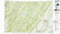
1983 Map of Winchester
USGS Topo · Published 1987About this map
The ridge-and-valley province of the northern Shenandoah Valley and the Eastern Panhandle is meticulously detailed in this early 1980s compilation. Centered on Winchester and the surrounding agricultural landscapes of Virginia and West Virginia, the map reveals a corridor of rapid development along Interstate 81 and the historic Route 11. Local history is anchored by rural landmarks such as the Old Iron Furnace and Greenway Court, while the region's industrial heritage is traced through the tracks of the Winchester and Western RR and the Norfolk and Western Ry.
Find a feature on this map
181 named features on this map. Tap any name to fly to it.
Don’t see what you’re looking for? This feature index may not catch every label — zoom into the map to look around manually.
Map Details
Editions of this 1983 Winchester Map
3 editions found
Other maps of this area

1884 · Harpers Ferry
USGS Topo · 1:125,000

1891 · Harpers Ferry
USGS Topo · 1:125,000

1891 · Romney
USGS Topo · 1:125,000

1892 · Franklin
USGS Topo · 1:125,000

1892 · Woodstock
USGS Topo · 1:125,000

1893 · Luray
USGS Topo · 1:125,000

1893 · Harpers Ferry
USGS Topo · 1:125,000

1894 · Warrenton
USGS Topo · 1:125,000

1894 · Winchester
USGS Topo · 1:125,000

1895 · Piedmont
USGS Topo · 1:125,000