
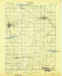
1918 Map of Winchester
USGS Topo · Published 1918About this map
The White River and Mississinewa River headwaters define this late-World War I era landscape across the Indiana and Ohio border. The city of Winchester serves as a major hub, where the Grand Rapids and Indiana RR crosses the Cleveland Cincinnati Chicago and St Louis RR. To the east, the sprawling rail junction at Union City highlights the region's industrial connectivity, featuring lines from the Traction Company and the Dayton and Muncie Electric RR.
Find a feature on this map
84 named features on this map. Tap any name to fly to it.
Don’t see what you’re looking for? This feature index may not catch every label — zoom into the map to look around manually.
Map Details
Editions of this 1918 Winchester Map
2 editions found
Other maps of this area

1908 · St. Henry
USGS Topo · 1:62,500

1915 · Fort Recovery
USGS Topo · 1:48,000

1915 · New Paris
USGS Topo · 1:48,000

1916 · Winchester
USGS Topo · 1:48,000

1918 · Fort Recovery
USGS Topo · 1:62,500

1918 · New Paris
USGS Topo · 1:62,500

1943 · Winchester
USGS Topo · 1:62,500

1952 · Maxville
USGS Topo · 1:24,000

1953 · Cincinnati
USGS Topo · 1:250,000

1953 · Muncie
USGS Topo · 1:250,000