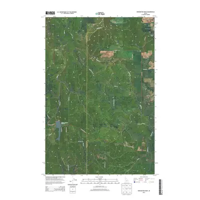
2013 Map of Winchester West
USGS Topo · Published 2013About this map
Winchester and its surrounding high-plateau landscape are captured in this 2013 survey, which highlights the divide between the Nez Perce and Lewis County border. The settlement of Winchester sits in the northeastern corner near the shores of Lapwai Lake, while the unincorporated community of Forest occupies the southern reach along Morrowtown Rd. The topography is defined by the significant descent of Mission Cr and Webb Cr, which carve deep drainages through the tableland.
Find a feature on this map
32 named features on this map. Tap any name to fly to it.
Don’t see what you’re looking for? This feature index may not catch every label — zoom into the map to look around manually.
Map Details
Editions of this 2013 Winchester West Map
This is the sole edition of this map. No revisions or reprints were ever made.
Other maps of this area

1946 · Limekiln Rapids
USGS Topo · 1:62,500

1955 · Pullman
USGS Topo · 1:250,000

1958 · Pullman
USGS Topo · 1:250,000

1958 · Sweetwater
USGS Topo · 1:24,000

1958 · Lewiston Orchards
USGS Topo · 1:62,500

1958 · Culdesac
USGS Topo · 1:62,500

1967 · Hoover Point
USGS Topo · 1:24,000

1967 · Westlake
USGS Topo · 1:24,000
1967 · Winchester East
USGS Topo · 1:24,000

1968 · Waha
USGS Topo · 1:24,000